GMAP Procedure
- Syntax

- Overview
- Concepts About Map Data SetsAbout GfK GeoMarketing Map Data SetsAbout Traditional Map Data SetsMap Data Sets Containing X, Y, LONG, and LATDifferences between GfK and Traditional Map Data Sets The METAMAPS Data SetSpecial GfK Data Sets for Annotating MapsSpecial Traditional Data Sets for Annotating MapsAbout Response Data SetsAbout Identification VariablesDisplaying Map Areas and Response DataSummary of UseAccessing SAS Maps OnlineImporting Maps from Esri Shapefiles
- Using
- Examples Using GfK GeoMarketing Map Data to Produce a Simple Block MapUsing Traditional Map Data to Produce a Simple Block MapUsing GfK GeoMarketing Map Data to Specify Response Levels in a Block MapUsing Traditional Map Data to Specify Response Levels in a Block MapUsing GfK GeoMarketing Map Data to Assign a Format to the Response VariableUsing Traditional Map Data to Assign a Format to the Response VariableUsing GfK GeoMarketing Map Data When Specifying the Statistic for the Response VariableUsing Traditional Map Data When Specifying the Statistic for the Response VariableUsing GfK GeoMarketing Map Data to Produce a Simple Choropleth MapUsing Traditional Map Data to Produce a Simple Choropleth MapUsing GfK GeoMarketing Map Data When Labelling Provinces on a MapUsing Traditional Map Data When Labelling Provinces on a MapUsing GfK GeoMarketing Map Data to Produce a Simple Prism MapUsing Traditional Map Data to Produce a Simple Prism MapUsing GfK GeoMarketing Map Data When Specifying Midpoints in a Prism MapUsing Traditional Map Data When Specifying Midpoints in a Prism MapUsing GfK GeoMarketing Map Data to Produce a Simple Surface MapUsing Traditional Map Data to Produce a Simple Surface MapUsing GfK GeoMarketing Map Data While Rotating and Tilting a Surface MapUsing Traditional Map Data While Rotating and Tilting a Surface MapMapping an Individual Country By Subsetting MAPS.WORLDUsing GfK GeoMarketing Map Data to Specify Country Subdivisions on a ContinentUsing GfK GeoMarketing Map Data to Produce a Choropleth Map Combining Three Map Data SetsUsing GfK GeoMarketing Map Data to Produce a Choropleth Map Annotating Cities
Creating SAS Map Data Sets
Creating Map Data Sets
Overview
In addition to using
map data sets that are supplied with SAS/GRAPH software, you can also create your own map data sets.
Map data sets are not limited to geographic data; you use them to
define other spaces such as floor plans.
The X and Y variable
values in the GfK map data set do not have to be in any specific units.
They are rescaled by the GMAP procedure based on the minimum and maximum
values in the data set. The minimum X and Y values are in the lower
left corner of the map, and the maximum X and Y values are in the
upper right corner.
The GMAP procedure uses
the values of the X and Y variables to draw the map. To use the unprojected
values to produce a custom map, follow the tasks in Map Data Sets Containing X, Y, LONG, and LAT.
Map data sets in which
the X and Y variables contain longitude and latitude should be projected
before you use them with PROC GMAP. See GPROJECT Procedure for details.
Other variables to consider
including in map data sets are:
-
a variable named SEGMENT to identify map areas that comprise noncontiguous polygons. Each unique value of the SEGMENT variable within a single map area defines a distinct polygon. If the SEGMENT variable is not present, each map area is drawn as a separate closed polygon that indicates a single segment.The observations for each segment of a map area in the map data set must occur in the order in which the points are to be joined. The GMAP procedure forms map area outlines by connecting the boundary points of each segment in the order in which they appear in the data set. Eventually the last point is joined to the first point to complete the polygon. All the segments for each ID value must be contiguous within the map data set.
-
a variable named RESOLUTION to map detail level based on output resolution. Refer to RESOLUTION Variable Values for a list of the output resolutions associated with a RESOLUTION variable value.
A unit area is defined
by observations in the map data set that have the same identification
(ID) variable value. A unit area might be composed of a single polygon
or a collection of polygons. A polygon is defined by all of the observations
that have the same SEGMENT variable value within the same unit area.
-
If the unit area contains enclosed polygons (holes), such as lakes, then the SEGMENT variable has one value but the interior polygon is defined by separate boundaries. To separate boundaries, a missing X and Y value must be inserted at the separation point. For example, in the CANADA2 data set supplied with
SAS/GRAPH
Creating a Unit Area That Contains Multiple Polygons
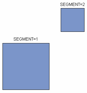
Use different
values of the SEGMENT variable to create separate polygons within
a single unit area. For example, this DATA step assigns two values
to the SEGMENT variable. The resulting data set produces a single
unit area that contains two polygons, as shown in Single Unit Area with Two Segments (Polygons):
data map;
   input id $ segment x y;
   datalines;
square   1 0 0
square   1 0 4
square   1 4 4
square   1 4 0
square   2 5 5
square   2 5 7
square   2 7 7
square   2 7 5
;
Creating a Unit Area That Contains Enclosed Polygons as Holes
Use separate boundaries to create
an enclosed polygon (that is, a polygon that falls within the primary
polygon for a single segment). The boundary for the hole is separated
from the primary polygon boundary by inserting a missing value for
X and Y. For example, the data set that is created by this DATA step
produces the map shown in Single Unit Area with Hole:
data map;
   input id $ segment x y;
   datalines;
square   1 0 0
square   1 0 4
square   1 4 4
square   1 4 0
square   1 . .
square   1 1 1
square   1 2 2
square   1 3 1
;
Note: A single map segment is a
section of a unit area with a single value of the SEGMENT variable.
A single map segment cannot contain multiple polygons without having
at least one observation with missing values for X and Y. All segments
within map data sets supplied by SAS/GRAPH
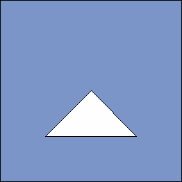
Creating a Unit Area That Contains Another Area
Sometimes rather than a hole
or lake, an enclosed polygon represents a separate map area. For example,
in MAPS.AFRICA, the country of Lesotho is surrounded by the country
of South Africa.
For example, this DATA
step creates a data set that produces the map shown in Unit Area within a Unit Area:
data map;
   input id $ segment x y;
   datalines;
square   1 0 0
square   1 0 4
square   1 4 4
square   1 4 0
square   1 . .
square   1 1 1
square   1 2 2
square   1 3 1
triangle 1 1 1
triangle 1 2 2
triangle 1 3 1
;