GMAP Procedure
- Syntax

- Overview
- Concepts About Map Data SetsAbout GfK GeoMarketing Map Data SetsAbout Traditional Map Data SetsMap Data Sets Containing X, Y, LONG, and LATDifferences between GfK and Traditional Map Data Sets The METAMAPS Data SetSpecial GfK Data Sets for Annotating MapsSpecial Traditional Data Sets for Annotating MapsAbout Response Data SetsAbout Identification VariablesDisplaying Map Areas and Response DataSummary of UseAccessing SAS Maps OnlineImporting Maps from Esri Shapefiles
- Using
- Examples Using GfK GeoMarketing Map Data to Produce a Simple Block MapUsing Traditional Map Data to Produce a Simple Block MapUsing GfK GeoMarketing Map Data to Specify Response Levels in a Block MapUsing Traditional Map Data to Specify Response Levels in a Block MapUsing GfK GeoMarketing Map Data to Assign a Format to the Response VariableUsing Traditional Map Data to Assign a Format to the Response VariableUsing GfK GeoMarketing Map Data When Specifying the Statistic for the Response VariableUsing Traditional Map Data When Specifying the Statistic for the Response VariableUsing GfK GeoMarketing Map Data to Produce a Simple Choropleth MapUsing Traditional Map Data to Produce a Simple Choropleth MapUsing GfK GeoMarketing Map Data When Labelling Provinces on a MapUsing Traditional Map Data When Labelling Provinces on a MapUsing GfK GeoMarketing Map Data to Produce a Simple Prism MapUsing Traditional Map Data to Produce a Simple Prism MapUsing GfK GeoMarketing Map Data When Specifying Midpoints in a Prism MapUsing Traditional Map Data When Specifying Midpoints in a Prism MapUsing GfK GeoMarketing Map Data to Produce a Simple Surface MapUsing Traditional Map Data to Produce a Simple Surface MapUsing GfK GeoMarketing Map Data While Rotating and Tilting a Surface MapUsing Traditional Map Data While Rotating and Tilting a Surface MapMapping an Individual Country By Subsetting MAPS.WORLDUsing GfK GeoMarketing Map Data to Specify Country Subdivisions on a ContinentUsing GfK GeoMarketing Map Data to Produce a Choropleth Map Combining Three Map Data SetsUsing GfK GeoMarketing Map Data to Produce a Choropleth Map Annotating Cities
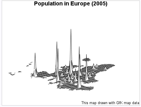
Example 19: Using GfK GeoMarketing Map Data While Rotating and Tilting a Surface Map
| Features: |
MAP= required argument referring to GfK map data DATA= argument referring to response data ID statement
|
| Other features: |
System option FMTSEARCH= SQL procedure |
| Data sets: | MAPSGFK.EUROPE (map data)
DEMOGRAPHICS (table of response data) |
| Format: | ison2a |
| Sample library member: | GMPGROSU |
CAUTION:
The GfK
GeoMarketing map data set used in this example is licensed to be used
only with SAS/GRAPH
Program
options fmtsearch=(sashelp.mapfmts);
proc sql;
create table demographics(drop=iso id rename=(oiso=iso isoalpha2=id)) as
select demo.*, names.id, names.isoalpha2,
  put(names.iso,z3.) as oiso format=$3.
from sashelp.demographics as demo
join
newnames as names
on names.id=demo.id
;
quit;
goptions reset=all border;
title1 "Population in Europe (2005)";
footnote1 j=r "This map drawn with GfK map data";
proc gmap map=mapsgfk.europe data=demographics;
id id;
surface pop / stat=mean
              constant=4
              nlines=100
              rotate=40
              tilt=60;
run;
quit;
Program Description
Create a table named demographics using sashelp.demographics
as the base and changing its variables to match GfK variable types
and lengths. This table will be used as the response data set. Note
that the ISO variable was numeric in the original sashelp.demographics
data but is the character variable OISO in the GfK map data set. The
format 'ison2a' uses the country's ISO numeric code to output the
country's ISO alpha2 code. Also note that the ID variable was a numeric
geographic locator code (glc) in the original sashelp.demographics
data but is represented by the ISOALPHA2 variable in the GfK map data
set.
proc sql;
create table demographics(drop=iso id rename=(oiso=iso isoalpha2=id)) as
select demo.*, names.id, names.isoalpha2,
  put(names.iso,z3.) as oiso format=$3.
from sashelp.demographics as demo
join
newnames as names
on names.id=demo.id
;
quit;
Produce the surface map.The
STATISTIC= option adds together all of the observations matching a
given ID value and this sum is divided by the number of nonmissing
observations matched. The CONSTANT= option specifies a value that
is less than the default value, resulting in spikes that are narrower
at the base. The NLINES= option specifies the maximum number of map
lines, which gives the best map shape resolution. The ROTATE= and
TILT= options adjust the map orientation to make the crowded spikes
in the northeast portion of the map easier to distinguish.