GEOCODE Procedure

Example 2: Street Geocoding
| Features: |
STREET geocoding method
|
| Other features: |
|
| Data set: | SASHELP.GEOEXM (primary street lookup data set |
| Sample library member: | GEOSTRT |
This example illustrates
the STREET geocoding method to obtain coordinates based on street
addresses with house numbers. The ATTRIBUTEVAR= option specifies an
additional variable to include in the output data set.
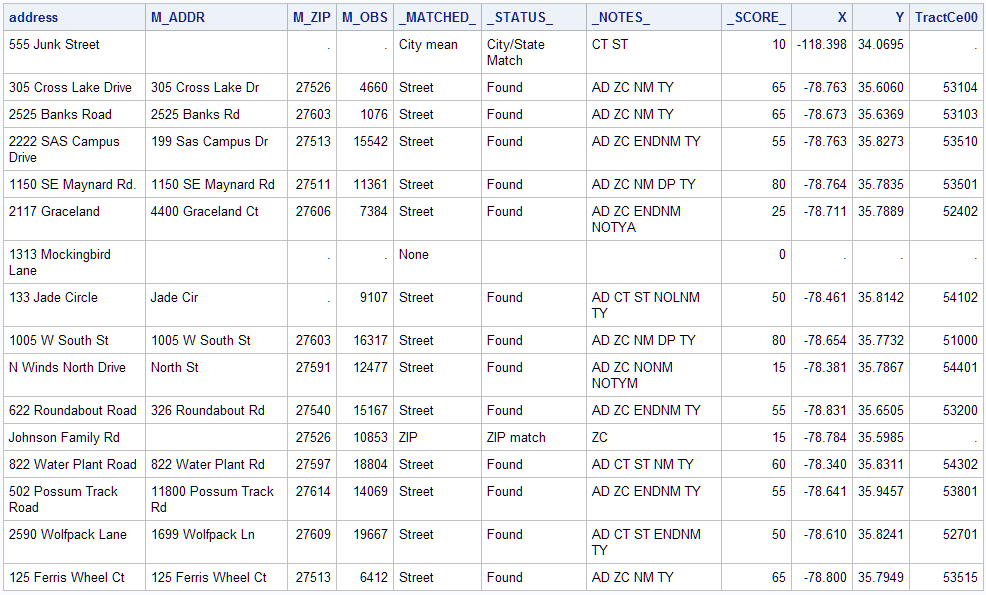
Output
Program
data WORK.CUSTOMERS (label='Input data for street geocoding');
  infile datalines dlm='#';
    length address $ 32
           city    $ 24
           state   $ 2;
   input address  /* House number and street name */
         zip      /* Customer ZIP code (numeric)  */
         city     /* City name                    */
         state;   /* Two-character postal code    */
datalines;
555 Junk Street # 99999 # Beverly Hills # CA
305 Cross Lake Drive # 27526 # Fuquay-Varina # NC
2525 Banks Road # 27603 # Raleigh # NC
2222 SAS Campus Drive # 27513 # Cary # NC
1150 SE Maynard Rd. # 27511 # Cary # NC
2117 Graceland # 27606 # Raleigh # NC
1313 Mockingbird Lane # # Delray # CC
133 Jade Circle # 27545 # Knightdale # NC
1005 W South St # 27603 # Raleigh # NC
N Winds North Drive # 27591 # Wendell # NC
622 Roundabout Road # 27540 # Holly Springs # NC
Johnson Family Rd # 27526 # #
822 Water Plant Road # # Zebulon # NC
502 Possum Track Road # 27614 # # NC
2590 Wolfpack Lane # 27604 # Raleigh # NC
125 Ferris Wheel Ct # 27513 # Cary # NC
;
run;
proc geocode                           /* Invoke geocoding procedure       */
   method=STREET                       /* Specify geocoding method         */
   data=WORK.CUSTOMERS                 /* Input data set of addresses      */
   out=WORK.GEOCODED                   /* Output data set with X/Y values  */
   lookupstreet=SASHELP.GEOEXM         /* Primary street lookup data set   */
   attributevar=(TRACTCE00);           /* Assign Census Tract to locations */
run;
proc print data=WORK.GEOCODED noobs;
   var address m_addr m_zip m_obs _matched_ _status_  _notes_ _score_ x y tractce00;
run;
quit;
Program Description
data WORK.CUSTOMERS (label='Input data for street geocoding');
  infile datalines dlm='#';
    length address $ 32
           city    $ 24
           state   $ 2;
   input address  /* House number and street name */
         zip      /* Customer ZIP code (numeric)  */
         city     /* City name                    */
         state;   /* Two-character postal code    */
datalines;
555 Junk Street # 99999 # Beverly Hills # CA
305 Cross Lake Drive # 27526 # Fuquay-Varina # NC
2525 Banks Road # 27603 # Raleigh # NC
2222 SAS Campus Drive # 27513 # Cary # NC
1150 SE Maynard Rd. # 27511 # Cary # NC
2117 Graceland # 27606 # Raleigh # NC
1313 Mockingbird Lane # # Delray # CC
133 Jade Circle # 27545 # Knightdale # NC
1005 W South St # 27603 # Raleigh # NC
N Winds North Drive # 27591 # Wendell # NC
622 Roundabout Road # 27540 # Holly Springs # NC
Johnson Family Rd # 27526 # #
822 Water Plant Road # # Zebulon # NC
502 Possum Track Road # 27614 # # NC
2590 Wolfpack Lane # 27604 # Raleigh # NC
125 Ferris Wheel Ct # 27513 # Cary # NC
;
run;proc geocode /* Invoke geocoding procedure */ method=STREET /* Specify geocoding method */ data=WORK.CUSTOMERS /* Input data set of addresses */ out=WORK.GEOCODED /* Output data set with X/Y values */ lookupstreet=SASHELP.GEOEXM /* Primary street lookup data set */ attributevar=(TRACTCE00); /* Assign Census Tract to locations */ run;