GEOCODE Procedure

Example 6: British Postcode Geocoding
| Features: |
ZIP geocoding method
|
| Other features: |
|
| Data set: | lookup.GBpostcodes (Postcode lookup data from MapsOnline) |
| Sample library member: | GEOZIPUK |
This example illustrates
the ZIP geocoding method using British Royal Mail postcodes. Lookup
data can be downloaded from SAS MapsOnline ( http://support.sas.com/rnd/datavisualization/mapsonline/html/downloads.html). See Non-U.S. Postcodes for details.
The LIBNAME statement assigns the library name LOOKUP
to the location where the GBpostcodes lookup data is installed. You
must edit the ‘pathname’ in the following LIBNAME statement
to reference the lookup data location on your system.
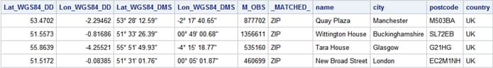
Generate the OFFICES input data set of addresses that
the GEOCODE procedure will use.Each
variable is delimited by a comma. Maximum variable lengths are specified.
An important step is to remove spaces and capitalize the postcode
values.
data offices;
  infile datalines dlm=',';
  length name city $24 postcode $8 country $2;
  input name                           /* Office name              */
        city                           /* Name of city             */
        postcode                       /* Royal Mail postcode      */
        country;                       /* Two-character country ID */
  postcode=upcase(compress(postcode)); /* Normalize postcodes      */
datalines;
Quay Plaza, Manchester, M50 3BA, UK
Wittington House, Buckinghamshire, SL7 2EB, UK
Tara House, Glasgow, G2 1HG, UK
New Broad Street, London, EC2M 1NH, UK
;
run;
Run the GEOCODE procedure with the generated OFFICES input
data set located in the WORK folder.The
GEOCODE procedure uses either the postcode or the city from each address
in the input data to match observations in the lookup data set.
proc geocode                     /* Invoke geocoding procedure            */
   method=zip                    /* Specify geocoding method              */
   data=work.offices             /* Input data set of offices             */
   out=geocoded_offices          /* Output data set of locations          */
   lookup=lookup.GBpostcodes     /* Postcode lookup data from MapsOnline  */
   addresszipvar=postcode        /* Postcode variable in input data       */
   lookupzipvar=pc               /* Postcode variable in lookup data      */
   lookuplongvar=Lon_WGS84_DD    /* Longitude variable in lookup data     */
   lookuplatvar=Lat_WGS84_DD     /* Latitude variable in lookup data      */
   attributevar=(lat_wgs84_dms   /* Additional variables from lookup data */
                 lon_wgs84_dms); /* set to assign to geocoded locations   */
run;