GPROJECT Procedure

About Coordinate Values
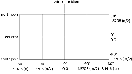
Longitude and Latitude Coordinates shows the
standard coordinate system for map data sets with coordinates in longitude
and latitude. For the longitude and latitude
values (below and to the right of the figure, respectively) the upper
value is expressed in degrees and the lower value is expressed in
radians. A radian is approximately 57.3 degrees.
By default, the GPROJECT
procedure assumes that the units for the input coordinate values are
radians and that values for the horizontal coordinate increase from
east to west across the map. If your map coordinates are stored as
degrees of arc, use the DEGREE option in the PROC GPROJECT statement.
If the horizontal coordinate values in the map increase west-to-east
rather than east-to-west, use the EASTLONG option in the PROC GPROJECT
statement.