GPROJECT Procedure

Example 1: Using Default Projection Specifications
| Features: |
ID statement |
| Sample library member: | GPJDEFLT |
This example demonstrates
the effect of using PROC GPROJECT on an unprojected map data set without
specifying any options. Because the PROJECT= option is not used in
the PROC GPROJECT statement, the Albers' equal-area projection method
is used by default. PROC GPROJECT supplies defaults for the standard
parallels that minimize the distortion of the projected map areas.
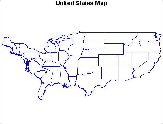
Map before Projection (GPJDEFLT(a)) illustrates the output produced by the US48 map data set,
which contains unprojected values in the X and Y variables. The US48 Data Set shows the variables in the data set.
The US48 Data Set
US48 Data Set
OBS STATE SEGMENT DENSITY X Y
1 1 1 3 1.48221 0.56286
2 1 1 3 1.48226 0.56234
3 1 1 3 1.48304 0.56231
.
.
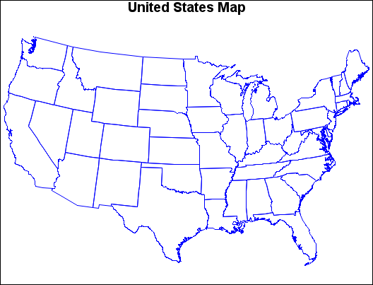
.The GPROJECT procedure
is used with the US48 map data set as input to create the projected
map data set, US48PROJ. The values for X and Y in this new data set
are projected (Cartesian). The US48PROJ Data Set shows the variables in the data set.
The US48PROJ Data Set
                             US48PROJ Data Set

          OBS       X           Y        DENSITY    STATE    SEGMENT

            1    0.16068    -0.073470       3         1         1
            2    0.16069    -0.073993       3         1         1
            3    0.16004    -0.074097       3         1         1
            .
            .
            .
The new projected map
data set, US48PROJ, is used to create the projected map, Map after Projection (GPJDEFLT(b)).
Program
goptions reset=all border;
data us48;
   set maps.states;
   if state ne 2 and state ne 15 and state ne 72;
run;
title "United States Map";
pattern value=mempty color=blue;
proc gmap map=us48 data=us48 all density=4;
   id state;
   choro state / nolegend levels=1;
run;
proc gproject data=us48
              out=us48proj;
   id state;
run;
proc gmap map=us48proj
          data=us48proj all density=4;
   id state;
   choro state / nolegend levels=1;
run;
quit;