GREDUCE Procedure

Using the GREDUCE Procedure
Specifying Density Levels
GREDUCE uses default criteria for determining
the appropriate DENSITY variable value for each observation in the
input map data set. If you do not want to use the default criteria,
use PROC GREDUCE options to select the following:
GREDUCE creates seven
density levels, numbered 0 through 6. Specify criteria for density
levels 1 through 5. You cannot define criteria for level 0, which
is reserved for map vertex points, such as common corners of unit
areas. You also cannot define criteria for level 6, which is assigned
to those points that do not meet the criteria for any lower level.
Specify the maximum
number of observations per density level using Nn=
in the PROC GREDUCE statement, and specify the minimum point distance
using En= . You must have
knowledge of the X and Y variable values in the particular input map
data set to determine appropriate values for En=.
See the En= option for details.
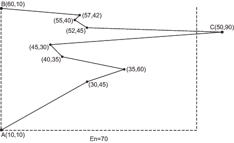
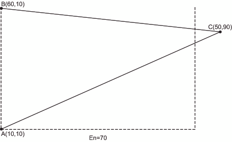
Points in Data Set before Reduction illustrates how to use the minimum distance parameter to
determine which points belong in a particular density level. At density
level n, only point C lies
at a distance greater than the En=
value (70) from a line between points A and B. Thus, after reduction
only point C remains between points A and B at density level n,
and the resulting reduced boundary is shown in Points in Data Set at Density n after Reduction. See Douglas and Peucker (1973) for details of the algorithm
used.
GREDUCE
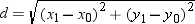
uses the usual Euclidean distance formula to determine the distance
between points. For example, the distance d between
the points (x0,y0)
and (x1,y1)
is GREDUCE uses the usual Euclidean distance formula to determine
the distance between points. For example, the distance d between
the points (x0,y0)
and (x1,y1)
is
If this distance function
is not suitable for the coordinate system in your input map data set,
transform the X and Y values to an appropriate coordinate system before
using GREDUCE. An example of inappropriate coordinates is latitude
and longitude values around one of the poles. In this case, the data
values should be projected before they are reduced. See GPROJECT Procedure for more information about map projection.
If you specify both
Nn= and En=
values for a density level, GREDUCE attempts to satisfy both criteria.
However, the number of points for any level is never reduced below
the number of points in density level 0. If you specify a combination
of Nn= or En=
values such that the resulting DENSITY values are not in order of
increasing density, a note is printed in the SAS log, and the DENSITY
values are calculated in increasing order of density.
Subsetting a Map Data Set
A map data set that is processed by GREDUCE does not
automatically result in a map that uses fewer points. By default,
the GMAP procedure produces a map that uses all of the points in the
map data set, even if the data set has been processed by the GREDUCE
procedure. To decrease the number of points that produce the map,
you must create a subset of the original data set using a DATA step
or the WHERE= data set option. For example, to create a subset of
a map that uses only the DENSITY values 0, 1, and 2, use this DATA
step:
data smallmap;
   set map;
   if density <= 2;
run;
Alternatively, you can
use WHERE= in the PROC GMAP statement:
proc gmap map=map(where=(density<=2))
          data=response;
Note: GREDUCE does not reduce the
size of the output map data set compared to the input map data set.
By default, the output map data set from PROC GREDUCE will be larger
than the input map data set because it contains all of the variables
and observations from the original data set, with the addition of
the DENSITY variable if it was not present in the original data set.
If the input map data set already had a DENSITY variable, the output
map data set will be the same size as the input map data set.