GEOCODE Procedure

Example 5: ZIP+4 Geocoding
| Features: |
PLUS4 geocoding method
|
| Other features: |
|
| Data set: | lookup.zip4 (from SAS MapsOnline) |
| Sample library member: | GEOZIP4 |
This example illustrates
the PLUS4 geocoding method using US Postal Service ZIP and ZIP+4 postal
codes. Lookup data can be downloaded from SAS MapsOnline ( http://support.sas.com/rnd/datavisualization/mapsonline/html/downloads.html). You can also purchase from Melissa Data the GEO*Data
product containing ZIP+4 centroids ( www.melissadata.com/geocoder/geodata.htm).
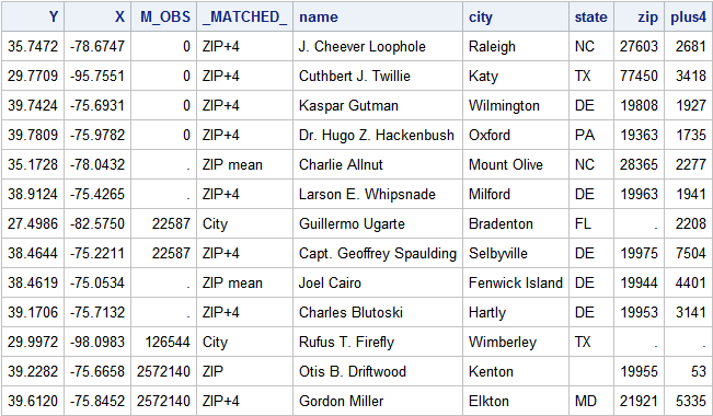
Output
The following output
from the PRINT procedure shows the GEOCODED_CUSTOMERS output data
set after running the GEOCODE procedure.
The example output
shows four results for the customer names and addresses submitted
as input. These include the location coordinates (X, Y), the matching
observation’s (row) number from the lookup data set (M_OBS),
and the method with which GEOCODE made the match.
The _MATCHED_ column
value in the output data set indicates how each address was located:
ZIP+4    - The ZIP and ZIP+4 values were matched. The location is the
center of the street segment.
ZIP mean - The ZIP+4 value was not matched and the GEOCODE procedure used
the ZIP method where multiple ZIP code matches were averaged.
ZIP      - The ZIP+4 value was not matched and the GEOCODE procedure used
the ZIP method where a single ZIP code match was found.
City     - Neither the ZIP+4 nor the ZIP code were found but the CITY
method returned a match.
The LIBNAME statement assigns the library name LOOKUP
to the location where the ZIP+4 lookup data is installed. You must
edit the ’pathname’ in the following LIBNAME statement
to reference the lookup data location on your system.
data customers;
   infile datalines dlm=',';
   length name city $32 state $2;
   input name      /* Customer name      */
         zip       /* Customer ZIP Code  */
         plus4     /* ZIP+4              */
         city      /* City name          */
         state;    /* State abbreviation */
datalines;
J. Cheever Loophole, 27603, 2681, Raleigh, NC
Cuthbert J. Twillie, 77450, 3418, Katy, TX
Kaspar Gutman, 19808, 1927, Wilmington, DE
Dr. Hugo Z. Hackenbush, 19363, 1735, Oxford, PA
Charlie Allnut, 28365, 2277, Mount Olive, NC
Larson E. Whipsnade, 19963, 1941, Milford, DE
Guillermo Ugarte, ., 2208, Bradenton, FL
Capt. Geoffrey Spaulding, 19975, 7504, Selbyville, DE
Joel Cairo, 19944, 4401, Fenwick Island, DE
Charles Blutoski, 19953, 3141, Hartly, DE
Rufus T. Firefly, ., ., Wimberley, TX
Otis B. Driftwood, 19955, 53, Kenton, ,
Gordon Miller, 21921, 5335, Elkton, MD
;
run;
Run the GEOCODE procedure with the generated CUSTOMERS
input data set. Specify that GEOCODE
use the PLUS4 method to look up each address.