GREMOVE Procedure

Example 1: Removing State Boundaries from U.S. Map
| Features: |
BY statement ID statement |
| Other features: |
SORT procedure, MERGE statement, and LIBNAME statement |
| Sample library member: | GRMUSMAP |
This example processes the MAPS.US map data set, supplied
with SAS/GRAPH, to produce a new map data set containing boundaries
for the U.S. Bureau of the Census divisions. Because the MAPS.US
map data set does not contain a variable to identify any unit area
other than states, this example creates a map data set that contains
the census divisions and that can be processed with the GREMOVE procedure.
The STATE variable in
the MAPS.US data set, containing numeric FIPS codes for each state,
is used as the BY-variable to merge the CBSTATES and MAPS.US data
sets. The MAPS.US Data Set shows some of the variables that are present in the data
set before using the GREMOVE procedure:
The MAPS.US Data Set
MAPS.US Data Set
OBS STATE SEGMENT X Y
1 1 1 0.16175 -0.10044
2 1 1 0.12305 -0.10415
3 1 1 0.12296 -0.10678
.
.
.
1524 56 1 -0.18757 0.15035
1525 56 1 -0.10158 0.13997
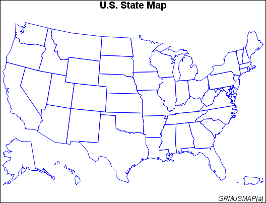
1526 56 1 -0.10398 0.11343And Map Before Removing Borders shows the map before processing:
The REMSTATE Data Set shows the variables that are present in the data set after
you use the GREMOVE procedure. Notice that the new map data set contains
a new variable called DIVISION:
The REMSTATE Data Set
REMSTATE Data Set
OBS X Y SEGMENT DIVISION
1 0.29825 0.17418 1 1
2 0.29814 0.17820 1 1
3 0.30206 0.18045 1 1
.
.
.
1082 -0.18715 -0.16010 8 9
1083 -0.18747 -0.15971 8 9
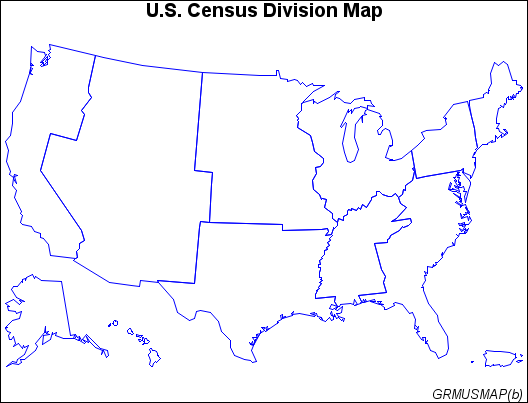
1084 -0.18747 -0.15951 8 9Map After Removing Borders shows the new map after PROC GREMOVE has removed interior
state boundaries.
Program
goptions reset=all border;
data cbstates;
   length state 8 stcode $ 2 division 4;
   input stcode division @@;
   state=stfips(stcode);
   drop stcode;
   datalines;
CT 1 MA 1 ME 1 NH 1 RI 1 VT 1 PA 2 NJ 2 NY 2 IL 3 IN 3 MI 3 OH 3 WI 3 IA 4 KS 4
MN 4 MO 4 ND 4 NE 4 SD 4 DC 5 DE 5 FL 5 GA 5 MD 5 NC 5 PR 5 SC 5 VA 5 WV 5
AL 6 KY 6 MS 6 TN 6 AR 7 LA 7 OK 7 TX 7 AZ 8 CO 8 ID 8 MT 8 NM 8 NV 8 UT 8
WY 8 AK 9 CA 9 HI 9 OR 9 WA 9
;
proc sort data=cbstates out=cbsort;
   by state;
run;
data uscb;
   merge cbsort maps.us;
   by state;
run;
proc sort data=uscb out=divstate;
   by division;
run;
proc gremove data=divstate out=remstate;
   by division;
   id state;
run;
title "U.S. State Map";
footnote j=r "GRMUSMAP(a) ";
pattern value=mempty color=blue;
proc gmap map=maps.us data=maps.us all;
   id state;
   choro state / nolegend levels=1;
run;
title "U.S. Census Division Map";
footnote j=r "GRMUSMAP(b) ";
proc gmap map=remstate data=remstate all;
   id division;
   choro division / nolegend levels=1;
run;
quit;
Program Description
Create data set CBSTATES. This
data set includes a variable, DIVISION, that contains the number of
the U.S. Bureau of the Census division for the state. This DATA step
converts letter codes to numeric FIPS codes that match those in the
STATE variable of MAPS.US.
data cbstates;
   length state 8 stcode $ 2 division 4;
   input stcode division @@;
   state=stfips(stcode);
   drop stcode;
   datalines;
CT 1 MA 1 ME 1 NH 1 RI 1 VT 1 PA 2 NJ 2 NY 2 IL 3 IN 3 MI 3 OH 3 WI 3 IA 4 KS 4
MN 4 MO 4 ND 4 NE 4 SD 4 DC 5 DE 5 FL 5 GA 5 MD 5 NC 5 PR 5 SC 5 VA 5 WV 5
AL 6 KY 6 MS 6 TN 6 AR 7 LA 7 OK 7 TX 7 AZ 8 CO 8 ID 8 MT 8 NM 8 NV 8 UT 8
WY 8 AK 9 CA 9 HI 9 OR 9 WA 9
;
Sort data set in FIPS-code order. Create a sorted data set, CBSORT. It can be properly
match-merged with the MAPS.US map data set, which is already sorted
in FIPS-code order.
Add DIVISION variable to map data set by merging the CBSORT
data set with MAPS.US. Create a new
map data set, USCB, that contains all of the state boundary coordinates
from the MAPS.US data set plus the added variable DIVISION.
Sort data set in DIVISION order. Sort USCB by the DIVISION variable to create the
DIVSTATE data set.
Remove interior boundaries within divisions. BY specifies the variable, DIVISION, in the input
map data set that identifies the new unit areas. ID specifies the
variable, STATE, in the input map data set that identifies the current
unit areas.