Using the SAS/GIS Interface

Starting SAS/GIS Software

Use the following steps to start a SAS/GIS software session:
  1. Open a SAS session.
  2. From the SAS menu bar, select Solutionsthen selectAnalysisthen selectGeographic Information System
Or type GIS in the SAS Command Box or on any SAS command line.

Using Dialog Box Elements

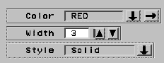
In most places where you must supply a value in a SAS/GIS window, you will see a pull-out arrow, a drop-down arrow, or both, presented in conjunction with text boxes, as shown in the following display.
Typical Dialog Box Elements
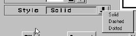
Clicking a drop-down arrow displays a list of valid choices for the option. List Displayed by the Style Drop-down Arrow shows the list that is displayed by clicking the drop-down arrow for the Style field in Typical Dialog Box Elements.
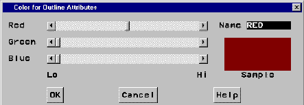
List Displayed by the Style Drop-down Arrow
Clicking a pull-out arrow opens a new window in which you can interactively select appropriate values. The following display shows the window that is opened by clicking the pull-out arrow for the Color field in Typical Dialog Box Elements.
Window That Is Opened by the Color Pull-out Arrow

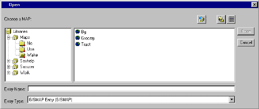
Selecting Maps and SAS Data Sets

Whenever you need to specify the name of a SAS data set or SAS catalog entry, SAS/GIS software opens an Open window like the one shown in the following display.
Typical Open Window
Typical Open Window
The window provides an intuitive way to find the SAS data set or catalog entry that you need. It also makes it impossible to enter an invalid name, because only those choices that are appropriate for the operation that you are performing are presented for selection.
To select each level of the SAS name from the tree view, double-click your choice. Once you make a selection, the list of available choices for the next level of the name is displayed.