Downloading TIGER/Line Spatial Data Files
Defining the Types of TIGER/Line Shapefiles Needed
This section discusses
how to differentiate and download the U.S. Census Bureau TIGER/Line
spatial data files that you need before importing them into SAS/GIS.
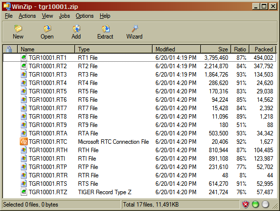
There are TIGER/Line shapefiles created between the years 1990 and
2006, which are ASCII files in the Record Type (RT) format. You can
also download compressed, zipped TIGER/Line shapefiles created from
2007 to the present.
TIGER shapefiles include
many different file types. However, SAS/GIS requires only three file
types: EDGES, FACES, and FEATNAMES. These specific shapefile file
types are imported into SAS/GIS chains, nodes, and details data sets.
You must unzip to extract the TIGER files to your system before you
can import them into SAS/GIS.
The U.S. Census Bureau
provides two methods for downloading TIGER/Line shapefiles. One is
a web-based interface and the other is a File Transfer Protocol (FTP)
site. Details of the required file types are next, followed by instructions
for downloading both RT and shapefiles with either the web interface
or the FTP method.
Required TIGER/Line Shapefile File Types
You do not need to download
all types of TIGER/Line shapefiles to create a SAS/GIS map. SAS/GIS
reads only the three file types listed in the following table. SAS/GIS
requires all three types for each geographical region imported.
|
TLID 1
3TFIDL, TFIDR
|
||||
|
TFID 2
|
||||
| 1A TIGER Line ID (TLID) is a number that uniquely identifies each feature line in TIGER data. The TLID provides linkage for each line among the various TIGER files. TLID values remain consistent across TIGER release years. | ||||
| 2A TIGER Face ID (TFID) is a number that uniquely identifies each polygon in TIGER data. TFID values remain consistent across various TIGER release years. | ||||
| 3Each line of a polygon edge has a unique TIGER Face ID number referencing the polygons on the left (TFIDL) and right (TFIDR) sides. | ||||
Downloading TIGER/Line Record Type (RT) Files (1990 – 2006)
The U.S. Census Bureau
provides an FTP site that enables you to transfer to your system multiple
TIGER RT format files simultaneously.
The FTP site is
ftp://ftp2.census.gov/geo/tiger/.
This FTP site contains various subdirectories organizing the TIGER
data by release year, geography, and file type. For example, some
year’s files are organized by state. The state folders contain
subfolders, one for each of its counties.
Downloading TIGER/Line Shapefiles (.shp) (2007 – present)
Interactive Web Method
There are different
web pages used to download TIGER files for specific years. Use the
main TIGER page to navigate to the download
site for a specific TIGER year: http://www.census.gov/geo/www/tiger/index.html.
An example of the main
download website for the U.S. Census Bureau layer file type selection
for 2012 TIGER/Line shapefiles is: http://www.census.gov/cgi-bin/geo/shapefiles2012/main. This site enables you to select one county at a time
to download. There are three layer file types that you need to select.
When you finish one file type, navigate back to the Main Download
Page to start selecting the next layer file type.
-
Note: From the drop-down menu, under the Features heading, submit the All Lines files. You will then select and submit a state. Then from the menu, select a county and click the Download button. Click the Save button when the File Download window is displayed. Specify the location where you want to write the zip file for the EDGES layer.
-
Note: From the drop-down menu, under the Feature Relationships heading, submit the Relationship Files selection. In the ensuing list, submit a state selection under the Topological Faces (polygons with all Geocodes) Shapefile heading. Then from the menu, select a county and click the Download button. Click the Save button when the File Download window is displayed. Specify the location where you want to write the zip file for the FACES layer.
-
Note: From the drop-down menu, under the Feature Relationships heading, submit the Relationship Files selection. In the ensuing list, submit a state selection under the Feature Names Relationship File heading. Then from the menu, select a county and click the Download button. Click the Save button when the File Download window is displayed. Specify the location where you want to write the zip file for the FEATNAME layer.
FTP Method
The U.S. Census Bureau
provides an FTP site that enables you to transfer to your system multiple
TIGER files simultaneously. This is a faster method than using the
web interface to download one file at a time.
This FTP site contains
various subdirectories organizing the TIGER data by release year,
geography and file type. Note that there are subfolders for the three
required file types needed, namely EDGES, FACES, and FEATNAMES.
Copyright © SAS Institute Inc. All rights reserved.