The GIS Spatial Data Importing Window
Opening the GIS Spatial Data Importing Window
The GIS
Spatial Data Importing window provides an interactive
facility for importing spatial data from other formats into SAS/GIS
spatial databases. You use the GIS Spatial Data Importing window
to specify the type of spatial data to import. To open the GIS
Spatial Data Importing window, select File Import from
the GIS Map window's menu bar, or select Import from
the map pop-up menu when no map is displayed.
Import from
the GIS Map window's menu bar, or select Import from
the map pop-up menu when no map is displayed.
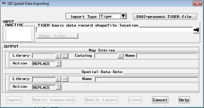
Elements of the GIS Spatial Data Importing Window
INPUT Pane
You use the INPUT pane
of the window to specify the location of the spatial data files that
you want to import. Additional information about each type of data
is presented later in this chapter.
The INPUT pane
contains the following three elements:
OUTPUT Pane
The OUTPUT pane
of the window contains the following two sections:
Map Entries
You specify the storage
location of the spatial database in this pane.
In the Library field,
you specify a name for the library that you want to contain the catalog
and its entries. You can enter the name of an existing library in
the field. You can also use the drop-down menu to select an existing
libref. Or you can use the pull-out menu to assign a new libref.
In the Catalog field,
you specify a name for the SAS catalog that you want to contain the
spatial database entries. You can enter the name of a new catalog
to be created. You can also enter the name of an existing catalog.
Or you can use the drop-down menu to select an existing catalog.
In the Name field,
you specify a name for the GIS map. By default, the Name field
contains the name of the spatial data import type (for example, TIGER,
ARC, DXF, and so on). You can supply your own GIS map name. This name
is also used for the coverage entry and as the base name of the polygonal
index data set. Use the first three letters of the name, and then
append up to the first five letters of the layer name.
Spatial Data Sets
In this pane, you specify
the name of the SAS library in which the chains, nodes, details, and
polygonal index data sets are stored. You also specify the base name
for the chains, nodes, and details data sets and spatial entry.
In the Library field,
you specify a name for the library that you want to contain the data
sets. You can enter the name of an existing library in the field.
You can also use the drop-down menu to select an existing libref.
Or you can use the pull-out menu to assign a new libref.
In the Name field,
you specify a base name for the data sets. The chains, nodes, and
details data set names are formed by adding a C, N, or D, respectively,
to this base name. The base name is also used as the name for the
spatial entry in the catalog.
Command Buttons
The command buttons
appear in a row along the lower edge of the GIS Spatial
Data Importing window. The following list describes the
different functions of the command buttons:
Modify Composites
opens a window to view
and modify the default composites that are created during the import.
Modify Layers
opens a window to view
and modify the default layer definitions that are created during the
import.
Close
closes the GIS
Spatial Data Importing window and returns to the GIS
Map window with the imported map displayed.
Copyright © SAS Institute Inc. All rights reserved.